
With over 700 miles of trails winding through glacier-carved valleys, towering peaks, and pristine wilderness, Glacier National Park is a hiker’s paradise. This guide features 17 unforgettable hikes that belong on every outdoor lover’s bucket list. We’ve included a mix of easy, moderate, and strenuous trails across the park’s most iconic areas—including Many Glacier, Two Medicine, West Glacier, and the Going-to-the-Sun Road—so you can plan your perfect Glacier hiking adventure!

From turquoise alpine lakes to jaw-dropping mountain passes, these hikes showcase the very best of Glacier National Park’s stunning terrain.
Whether you’re dreaming of an easy lakeside stroll, a family-friendly forest walk, or an ambitious all-day trek into Glacier National Park’s high country, this guide features 17 epic hikes that deserve a spot on every adventurer’s bucket list. From serene alpine lakes to panoramic passes, these handpicked trails showcase the best of Glacier’s jaw-dropping landscapes and diverse terrain.
We’ve included a balanced mix of easy, moderate, and strenuous hikes across all the park’s main regions—Many Glacier, Two Medicine, West Glacier, and the iconic Going-to-the-Sun Road—so you can easily plan the perfect hiking adventure no matter your experience level or time constraints.
To help you navigate the park more efficiently, this guide is organized by region. You’ll find the top-rated trails in West Glacier, unforgettable hikes along the Going-to-the-Sun Road, classic routes in Many Glacier, and hidden gems in the quieter Two Medicine area.
Each hike includes key details like distance, elevation gain, and estimated time, along with in-depth trail descriptions so you know exactly what to expect.
Whether you’re chasing waterfalls, craving solitude, hoping to spot wildlife, or eager to stand in the shadow of ancient glaciers, you’ll find the perfect trail for you in this Glacier National Park hiking guide!
Best Hikes in West Glacier
Trail of the Cedars

- Distance: 0.7 miles loop
- Elevation: Flat
- Time: 30 minutes
- Difficulty: Easy
- Trailhead: Avalanche Creek Picnic Area
Who is this hike for? This trail is ideal for beginners, visitors pressed for time, and anyone seeking a short, easy hike. It’s also wheelchair and stroller-friendly.
Trail Description: Trail of the Cedars is a loop trail that winds through an ancient forest of western red cedars and hemlock trees, some of which are over 500 years old!
Half of the trail will take you across a raised boardwalk, while the other half is compact dirt. You can begin the hike in either direction. The trailhead is located across the road from Avalanche Creek Picnic Area (5.5 miles from Lake McDonald Lodge).
Avalanche Lake

- Distance: 4.6 miles
- Elevation: 500 feet
- Time: 3-4 hours
- Difficulty: Moderate
- Trailhead: Avalanche Creek Picnic Area
- Read trail guide
Who is this hike for? This trail is perfect for hikers of all levels, and especially for beginners looking to challenge themselves on a moderate hike with minimal elevation gain. It’s also great for anyone looking to do a hike that won’t take up the whole day.
Trail Description: The Avalanche Lake Trail begins on the Trail of Cedars, leading you through an ancient forest of western red cedars and hemlock trees. After a short walk, you’ll reach a junction that marks the start of the trail to Avalanche Lake.
From here, the trail gently climbs through a forest, passing a small waterfall where icy-blue water rushes through a narrow slot canyon.
The trail continues to the breathtaking Avalanche Lake, where you’ll be awestruck by its stunning emerald-green water, framed by towering mountains and cascading waterfalls. Along the lake’s shoreline you’ll find a wide beach area to sit and soak in the magnificent scenery.
>>Read: Avalanche Lake Hike: Everything You Need to Know Before You Go
Upper McDonald Creek Trail

- Distance: 5.3 miles
- Elevation: 210 feet
- Time: 2-4 hours
- Difficulty: Moderate
- Trailhead: Upper McDonald Creek Trailhead
Who is this hike for? This trail is ideal for those seeking a peaceful, half-day hike in the Lake McDonald Valley. It offers a quiet escape away from the crowds, without venturing too far from Going-To-The-Sun Road.
Trail Description: The Upper McDonald Creek Trail begins at a trailhead off North Lake McDonald Road. The parking area accommodates several vehicles with additional spots near the McDonald Creek Bridge.
You’ll start along a gravel footpath through a dense, old-growth forest, like those typically found in the Pacific Northwest. Roughly three-tenths of a mile from the trailhead is the spectacular McDonald Falls.
During spring, this is a great spot for watching Harlequin ducks which migrate inland at this time of year to breed and raise their young along turbulent mountain streams. Harlequins are relatively rare in Montana, and Glacier National Park’s Upper McDonald Creek has the highest density of breeding harlequin ducks in the contiguous United States.
Just past McDonald Falls, you’ll reach Sacred Dancing Cascades, then continue onto a large wetland area alongside an oxbow bend on McDonald Creek. This area is prime moose habitat, especially in the morning and late afternoons.
Next you’ll reach Avalanche Creek Overlook, a wooden platform that overlooks the creek on the opposite bank, and finally a boulder field which marks the end of the hike. Looking upstream is Mount Cannon which rises almost 5600 feet above the valley floor. This is a great spot to relax and have lunch before heading back.
Best Hikes Along Going-To-The-Sun Road
The Going-to-the-Sun Road stretches 50 miles across Glacier National Park, connecting West Glacier to the east side at St. Mary. This iconic alpine highway offers nonstop jaw-dropping scenery, with one breathtaking viewpoint after another.
Along the route you’ll find some of the park’s most legendary hiking trails—including the famed Highline Trail. Below are the best hikes to explore along the Going-to-the-Sun Road.
Hidden Lake Overlook

- Distance: 2.8 miles
- Elevation: 460 feet
- Time: 1-2 hours
- Difficulty: Moderate
- Trailhead: Logan Pass Visitor Center
Who is this hike for? This hike is perfect for both beginners and experienced hikers. Beginners can hike to Hidden Lake Overlook, while experienced hikers can continue from there to the lake’s shoreline for a more challenging adventure (5.2 miles return trip).
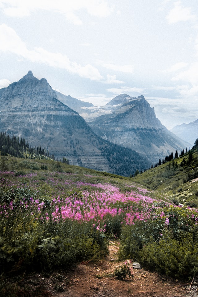
Trail Description: This hike starts at the Logan Pass Visitor Center and climbs a series of wooden steps and boardwalks across a beautiful alpine meadow filled with wildflowers.
About a half mile into the hike, the boardwalk section ends. From here you’ll head towards Bearhat Mountain, while Mt. Reynolds and Heavy Runner Mountain will be on your left. Before long, you’ll arrive at the Hidden Lake Overlook where you’ll witness outstanding panoramic views of Hidden Lake and the surrounding mountains.
Adventurous hikers can continue another 1.4 miles down to the lake’s northeastern shore. The trail descends steeply along a set of switchbacks, which you will have to climb back up on the return trip.
Wildlife sightings are common along the Hidden Lake Overlook Trail. Keep an eye out for Bighorn sheep, mountain goats, marmots, weasels, pikas, and grizzly bears. Even though this hike is short, you should carry bear spray.
Also expect heavy crowds as this is one of the most popular hikes in Glacier National Park. Plan to arrive extremely early as getting a parking spot at the Logan Pass Visitor Center can be very difficult.
Highline Trail

- Distance: 11.8 miles one-way
- Elevation: 1,950 feet
- Time: 8-9 hours
- Difficulty: Strenuous
- Trailhead: Logan Pass Visitor Center
Who is this hike for? This trail is best suited for advanced hikers who are ready for a long day hike. If you only have a day or two in Glacier National Park, make this hiking trail your top priority.
Trail Description: This amazing adventure starts at the Logan Pass Visitor Center. The beginning of the trail travels across a scenic alpine meadow before hugging the cliffs of The Garden Wall, where you’ll walk along a narrow ledge that’s only six feet wide. With steep drop-offs, this section is a bit intimidating, but ropes are provided to help with balance.
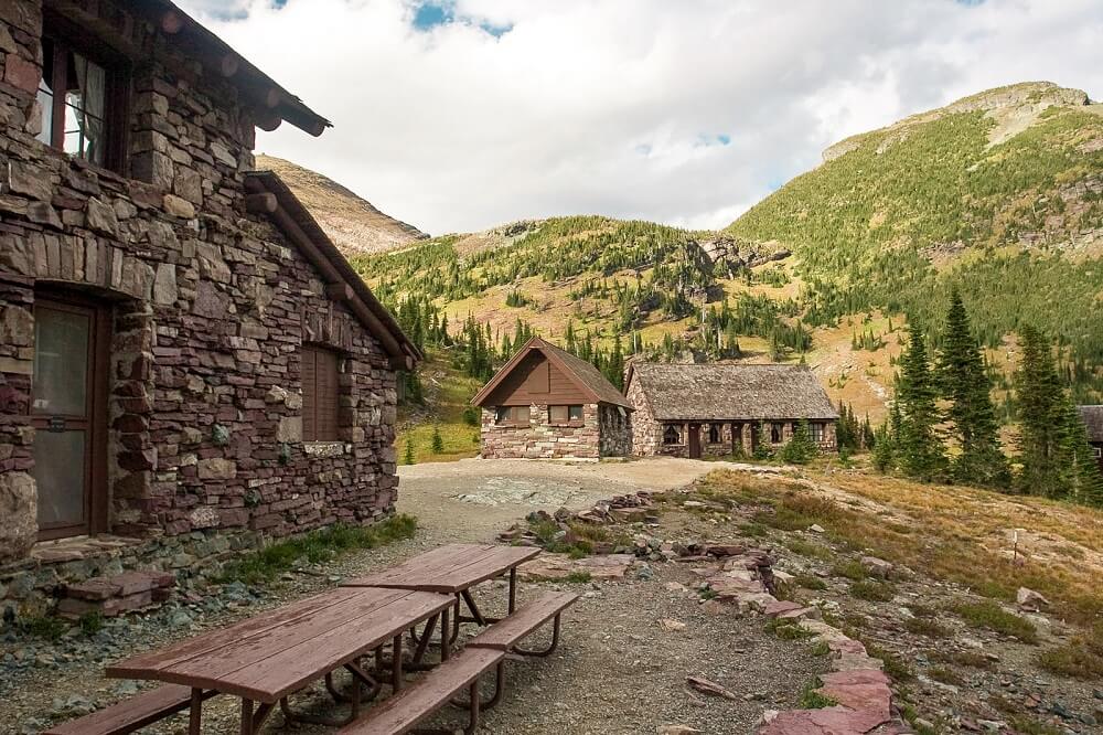
At 3.6 miles, you’ll reach Haystack Pass, where some hikers choose to turn back. For those continuing, the trail gently descends until you reach Granite Park Chalet at 7.6 miles. Built in 1914, this historic chalet offers a perfect spot to rest before tackling the final stretch.
The last part of the trail descends steeply—be prepared for tired legs as you make your way down. But don’t worry, the effort is worth it. You’ll have completed one of the most unforgettable hikes in the U.S.
Expect breathtaking views of alpine meadows, valleys and towering peaks the entire way. And likely a few wildlife encounters too!
Travel Tip: Since this is a one-way trail, you’ll need to catch a shuttle bus back to Logan Pass or hike back the way you came. Plan ahead to avoid missing the last shuttle!
Granite Park Chalet Via The Loop
- Distance: 8.4 miles
- Elevation: 2,600 feet
- Time: 5-6 hours
- Difficulty: Strenuous
- Trailhead: The Loop
Who is this hike for? This trail offers a shorter alternative to the Highline Trail, but it’s still a steep ascent, so be prepared for a challenging climb. It’s best suited for hikers in good physical condition who are ready for some serious elevation gain.
Trail Description: Starting at The Loop (13 miles from Lake McDonald Lodge), this hike ascends sharply through a forested mountainside. Over the next 3.5 miles, you’ll climb 2,400 feet to reach Granite Park Chalet, a historic backcountry lodge built in 1914 by the Great Northern Railway.
Along the way, take time to enjoy sweeping views of McDonald Creek, Lake McDonald Valley, and Heavens Peak (8,987 feet). At 4.2 miles, you’ll reach a junction with the Highline Trail. Follow the path straight ahead toward Fifty Mountain Campground and continue on to the chalet.
Granite Park Chalet, a National Historic Landmark, offers rustic accommodations for hikers, featuring twelve rooms with six bunks each. Though it’s without electricity, the chalet does have running water, providing a unique opportunity to experience Glacier’s backcountry without roughing it completely.
Travel Tip: For a memorable experience, consider booking a stay at Granite Park Chalet. Reservations fill up quickly, so plan a year in advance to secure a spot.
Siyeh Pass

- Distance: 9 miles
- Elevation: 2,090 feet
- Time: 5-6 hours
- Difficulty: Strenuous
- Trailhead: Siyeh Bend Trailhead
Who is this hike for? The Siyeh Pass Trail is ideal for intermediate to experienced hikers seeking a challenging, less crowded alternative to Glacier’s more popular trails. The trail is typically hiked out-and-back, but can be done as a one-way trip using the park shuttle.
Trail Description: This hike begins at the Siyeh Bend Trailhead, two miles east of Logan Pass. The trail starts alongside Siyeh Creek before entering a dense spruce-fir forest. At one mile, turn left at the Piegan Pass junction to stay on the Siyeh Pass Trail.
At 2.7 miles in, turn right at the second junction to continue toward Siyeh Pass. Soon you’ll enter Preston Park, a stunning glacier-carved valley blanketed with wildflowers and surrounded by dramatic peaks. Bears are common here so make noise and stay alert.
After crossing Siyeh Creek at mile 3.5, the trail climbs 700 feet up steep switchbacks to reach the saddle between Matahpi Peak and Mount Siyeh. The views from the top of Goat Mountain, Piegan Mountain, and Heavy Runner Mountain are incredible.
From here, return the way you came, or continue for another 5.6 miles down to Sunrift Gorge, descending a series of steep switchbacks with amazing views of Sexton Glacier, St. Mary Lake, and scenic waterfalls. Catch the park shuttle back from the bottom.
Travel Tip: For a point-to-point option, continue past Siyeh Pass for 5.6 miles through Baring Creek Valley to Sunrift Gorge, where you can catch the park shuttle back. But be prepared for a steep 1,450-foot descent over 2.5 miles of switchbacks, followed by more switchbacks before the trail levels out. Despite the challenge, you’ll be rewarded with incredible views of Sexton Glacier, St. Mary Lake, and several waterfalls along the way.
Out-and-Back (to Siyeh Pass)
- Distance: 6.7 miles
- Elevation Gain: 2,300 feet
- Difficulty: Challenging (steep final ascent)
Point-to-Point (Siyeh Pass to Sunrift Gorge)
- Distance: 12.3 miles (Siyeh Pass to Sunrift Gorge)
- Elevation Gain/Loss: +2,300 feet to Siyeh Pass, -3,750 feet descent (steep)
- Difficulty: Very challenging (long descent, multiple switchbacks)
- Highlights: Amazing views of Sexton Glacier, St. Mary Lake, and waterfalls
St Mary & Virginia Falls

- Distance: 3.6 miles
- Elevation: 525 feet
- Time: 1-3 hours
- Difficulty: Easy
- Trailhead: St. Mary Falls Trailhead
Who is this hike for? This is the perfect hike for anyone seeking a short, easy, and rewarding trail along Going-to-the-Sun Road. With two stunning waterfalls, aqua-green pools, and sweeping mountain views, it’s a must-do for photographers, families, and casual hikers alike.
Trail Description: The hike to St. Mary Falls and Virginia Falls starts at the St. Mary Falls Shuttle Stop, about 10 miles west of the St. Mary entrance to Glacier National Park.
From the shuttle stop, take the St. Mary Falls Cutoff Trail, descending through forest recovering from the 2015 Reynolds Creek Fire. After about a quarter mile, turn right at the Piegan Pass Trail junction, then quickly veer left onto the St. Mary Lake Trail.
Follow the sound of rushing water for another 0.4 miles to reach St. Mary Falls, a stunning 35-foot waterfall cascading in three tiers. The upper two tiers are especially photogenic, and the spray from the narrow gorge offers a refreshing break.
To continue to Virginia Falls, follow the trail uphill along Virginia Creek, passing two scenic, unnamed cascades—one with four dramatic tiers. At the next trail fork, stay right and in just a few steps you’ll arrive at Virginia Falls.
This 50-foot, multi-tiered waterfall tumbles over rugged rock and is even more impressive up close. Cool off in the spray, snap some photos, and enjoy one of Glacier’s most iconic and accessible waterfall hikes.
Best Hikes in Many Glacier
Many Glacier is home to some of Glacier National Park’s most iconic hikes, including the unforgettable journeys to Grinnell Glacier and Iceberg Lake. But this region isn’t just for experienced hikers — you’ll also find several short, easy trails perfect for beginners and families.
Below is a list of the top hikes in the Many Glacier area. For a more in-depth guide, be sure to check out our full post on the best hikes in Many Glacier.
Swiftcurrent Lake Nature Trail

- Distance: 2.7 miles
- Elevation: Flat
- Time: 1-2 hours
- Difficulty: Easy
- Trailhead: Grinnell Glacier Trailhead or Many Glacier Hotel
Who is this hike for? This scenic loop is ideal for beginner hikers, families with young children, or anyone looking for an easy nature walk with beautiful views and wildlife-spotting opportunities.
Trail Description: The Swiftcurrent Lake Nature Trail is a leisurely loop that circles Swiftcurrent Lake. This easy trail offers panoramic lake and mountain views, including striking perspectives of Grinnell Point (7,600 ft) and Mount Wilbur (9,321 ft).
You can begin this hike at either Grinnell Glacier Trailhead or Many Glacier Hotel, the loop works well in either direction. The first quarter-mile past the Grinnell Glacier Trailhead is wheelchair accessible, making this a great choice for visitors with limited mobility.
For the best experience, start at the Many Glacier Hotel. From here, the trail meanders through a peaceful forest of lodgepole pine, spruce, fir, and aspen, with occasional peek-a-boo views of the surrounding peaks.
You’ll pass several lakeside beach areas perfect for a picnic, a break in the sun, or even a refreshing swim.
Midway through the loop, you’ll cross a footbridge over Swiftcurrent Creek, a popular spot to watch for moose in the nearby wetlands. Shortly after, you’ll come to a boat dock, where the views back toward the Many Glacier Hotel are especially photogenic.
As you complete the loop, continue through another stretch of forest where bear activity is common, so stay alert and make noise. The trail eventually returns you to the hotel, completing a relaxing and rewarding walk in one of Glacier’s most picturesque areas.
Grinnell Glacier

- Distance: 10.6 miles
- Elevation: 1,600 feet
- Time: 5-7 hours
- Difficulty: Strenuous
- Trailhead: Grinnell Glacier Trailhead or Many Glacier Hotel
Who is this hike for? This trail is perfect for intermediate to advanced hikers who want to experience the very best of Glacier National Park in just one day. With a little determination, even motivated beginner hikers can tackle this unforgettable adventure.
Trail Description: From glaciers and alpine lakes to towering peaks and wildflower-filled meadows, the Grinnell Glacier Trail showcases the park’s most iconic scenery.
Often hailed as one of the top hikes in Glacier National Park, the trail to Grinnell Glacier is a must for any outdoor enthusiast. It’s the only day hike in the park that brings you face-to-face with an active glacier, making it an essential experience for those who want a deeper connection with the park’s glacial landscape.
The trail begins either at the Grinnell Glacier Trailhead or at Many Glacier Hotel. For the first two miles, the trail gently follows the scenic shores of Swiftcurrent Lake then Lake Josephine, offering serene views with only a slight elevation gain.
Once you reach the far end of Lake Josephine, the trail begins to climb more steeply, ascending into the heart of Grinnell Valley. This section offers breathtaking overlooks of Grinnell Lake below and the surrounding mountains.
You’ll hike through lush alpine meadows and may even spot wildlife such as grizzly bears, mountain goats, or bighorn sheep—so stay alert and keep your bear spray handy.
The final stretch brings you to Upper Grinnell Lake, nestled beneath the towering Garden Wall. Here, you’ll see Grinnell Glacier up close, with its icy blue crevasses and melting edges cascading into the lake. It’s a sight that few trails in the continental U.S. can offer and one that leaves a lasting impression.
Travel Tip: To shorten the hike by about 1.7 miles, you can book a boat ride across Swiftcurrent Lake and Lake Josephine with Glacier Park Boat Company. While this option saves time, keep in mind that it does not eliminate the steep elevation gain later in the hike.
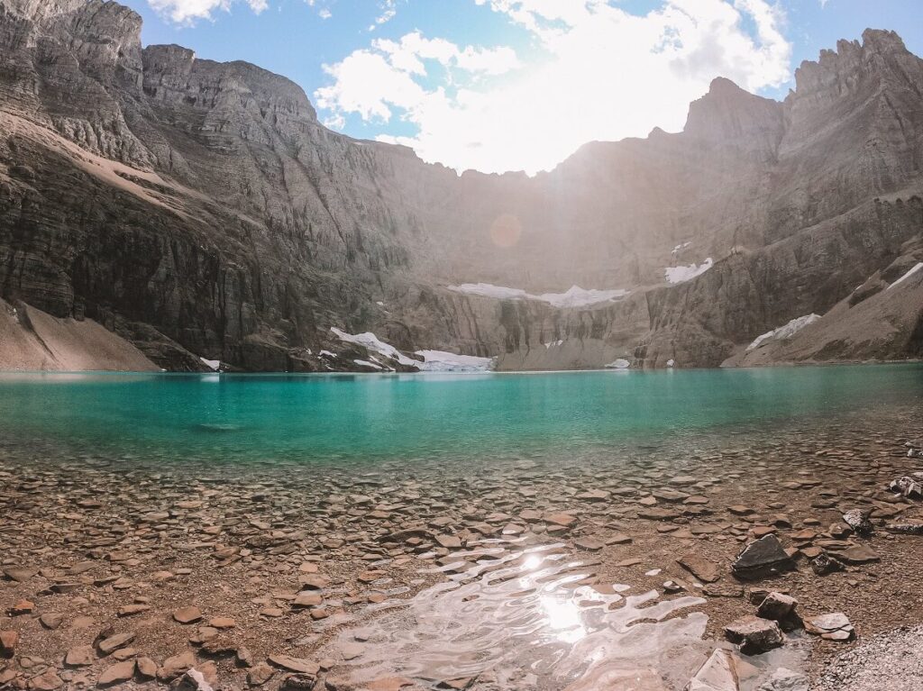
Iceberg Lake
- Distance: 9.6 miles
- Elevation: 1,200 feet
- Time: 5-7 hours
- Difficulty: Moderate
- Trailhead: Iceberg Ptarmigan Trailhead
- Read trail guide
Who is this hike for? This trail is ideal for intermediate to advanced hikers who have a couple of days to explore the Many Glacier area and are looking for a stunning alternative or follow-up to the Grinnell Glacier hike. It’s especially perfect if you want a slightly less crowded trail that still delivers jaw-dropping alpine scenery.
Trail Description: The Iceberg Lake Trail is undoubtedly one of the most rewarding hikes in Glacier National Park. Leading you through a dramatic alpine valley to a surreal turquoise lake tucked beneath towering cliffs, this trail is a photographer’s dream and a must for any hiking enthusiast.
The hike begins at the Iceberg Ptarmigan Trailhead, located behind the Swiftcurrent Motor Inn. From the start, you’re treated to wide-open views of surrounding peaks like Mount Grinnell (8,851 ft), Swiftcurrent Mountain (8,436 ft), and Mount Wilbur (9,321 ft). After this open stretch, the trail enters a forested area where it continues to gently climb.
For the first 2.7 miles, the Iceberg Lake Trail shares its path with the Ptarmigan Tunnel Trail. At Ptarmigan Falls, you’ll reach a junction—stay left to continue toward Iceberg Lake. The next section winds through shady forest before opening up once again, revealing your first views of the towering cirque that cradles Iceberg Lake.
As you near the end of the hike, the trail passes through a vibrant alpine meadow filled with wildflowers in summer. Soon after, you’ll arrive at Iceberg Lake itself—a jaw-droppingly aquamarine glacially carved lake nestled beneath vertical rock walls that soar nearly 3,000 feet above the water.
If you visit early in the season, you may be lucky enough to witness actual icebergs floating in the lake—a rare and fascinating sight that makes this destination truly live up to its name. And if you’re feeling bold, take a quick dip in the frigid water — just don’t expect to stay in long!
>>Read: Iceberg Lake Hike: A Must-Do Trail in Glacier National Park
Cracker Lake

- Distance: 13 miles
- Elevation: 1,900 feet
- Time: 7-9 hours
- Difficulty: Strenuous
- Trailhead: Many Glacier Hotel
Who is this hike for? The Cracker Lake Trail is best suited for experienced hikers who are comfortable with long day hikes. It’s a great choice if you’ve already tackled Glacier’s more popular trails and are looking to explore less-traveled terrain with stunning alpine scenery—minus the crowds.
Trail Description: Often overlooked, the hike to Cracker Lake is one of Glacier National Park’s most underrated gems. While it requires a full-day effort, the reward is a striking turquoise lake set against a dramatic backdrop of soaring peaks—truly a hidden treasure in the Many Glacier region.
The trail begins at the Many Glacier Hotel parking lot, where signage leads you onto a narrow forest path that wraps around Sherburne Lake. Around one mile in, you’ll reach Cracker Flats, an open area with gorgeous views of the lake, before reentering the forest and crossing several streams via wooden bridges.
From here, the trail begins a gradual climb along switchbacks leading up a ridge with views of Canyon Creek on your left and Allen Creek on the right. At around 3 miles, the trail briefly opens up before diving back into the woods for another stretch.
When the trail emerges again at 4.5 miles, you’ll enter open terrain with sweeping views of Mount Siyeh (10,014 ft) and Allen Mountain (9,376 ft) straight ahead.
At 5.8 miles you’ll reach the north shore of Cracker Lake, where its vivid turquoise water and towering cliffs are guaranteed to leave you in awe. While you could turn back here, it’s worth hiking an additional half mile to a rocky overlook for the best panoramic views.
Still have energy? Continue to the historic Cracker Lake Mine Site, established in 1897 after copper was discovered. While entering the mine is prohibited, you can explore the area’s abandoned equipment and tailings—just be cautious, as some materials may be toxic.
The trail officially ends at the lake’s southern shoreline, where there’s a backcountry campground with three sites. If you’re planning to stay overnight, don’t forget to secure a backcountry permit in advance.
Travel Tip: This trail is also shared with guided horseback tours operated out of Many Glacier. For a unique alternative to hiking, consider booking a Cracker Lake horseback ride with Many Glacier Trail Rides.
Best Hikes in Two Medicine
Two Medicine is one of Glacier National Park’s quieter and more underrated regions, making it a great destination for those looking to escape the crowds. This area offers a mix of scenic trails from easy strolls to challenging backcountry routes. Below are some of the best hikes to explore in Two Medicine.
Running Eagle Falls

- Distance: 0.6 miles
- Elevation: Flat
- Time: 30 minutes
- Difficulty: Easy
- Trailhead: Running Eagle Falls Trailhead
Who is this hike for? This trail is ideal for anyone looking for a short, easy, and rewarding walk—perfect for families, beginners, or travelers short on time. If you love waterfalls and cultural history, Running Eagle Falls is a must-see.
Trail Description: The hike to Running Eagle Falls begins at its dedicated trailhead, located just one mile from the Two Medicine entrance station. This trail is wide, flat, and accessible, making it one of the most relaxing and approachable hikes in Glacier National Park.
You’ll start by walking through a peaceful stretch of forest before emerging into a broad riverbed. A footbridge spans the creek, offering your first view of Running Eagle Falls.
To get an even closer look, cross the bridge and follow the path across a few rocks along the riverbank to the base of the falls.
The falls are named in honor of Running Eagle, a Blackfeet woman warrior from the early 1700s. After completing a four-day vision quest in the mountains above the falls, she became the only woman in her tribe to lead war parties and be given a man’s name—an extraordinary distinction in Blackfeet culture.
Pitamakan-Dawson Loop

- Distance: 17.4 miles
- Elevation: 2,968 feet
- Time: 10-12 hours
- Difficulty: Strenuous
- Trailhead: Two Medicine Lake
Who is this hike for? This challenging 17.4 mile loop is best suited for experienced hikers or strong backpackers seeking an epic day in Glacier’s backcountry.
Trail Description: Traversing two dramatic valleys and two scenic passes along the Continental Divide, the Dawson-Pitamakan Loop Trail offers nonstop alpine beauty, sweeping mountain vistas, and prime wildlife viewing. Expect wildflower-filled meadows, steep climbs, and breathtaking panoramas that make the effort more than worthwhile!
The loop begins along the North Shore Trail at Two Medicine Lake. For a more leisurely start, consider taking the Two Medicine boat shuttle across the lake, cutting off several miles and offering spectacular views of the surrounding peaks.
From the lake’s far shore, the trail climbs steadily through Bighorn Basin on its way to Dawson Pass, unveiling jaw-dropping views of the Lewis Range.
After reaching Pitamakan Overlook, the route curves around the north side of Mount Morgan before descending to Pitamakan Pass, another incredible high-mountain vantage point.
The trail then drops into the rugged Dry Fork Valley, winds around the eastern base of Rising Wolf Mountain, and eventually loops back to the North Shore Trailhead where you began.
Travel Tip: To fully appreciate the stunning scenery without the time crunch, consider turning this hike into an overnight backpacking trip. Backcountry campsites near No Name Lake and Old Man Lake provide serene alpine camping experiences—but be sure to obtain a backcountry permit in advance.
Tips for hiking in Glacier National Park

1. Start Early
Parking lots at popular trailheads fill up quickly, especially in summer. Begin your hikes early in the morning to secure parking, avoid crowds, and enjoy cooler temperatures and better lighting for photos.
2. Stay Hydrated and Bring Snacks
Even moderate hikes can be strenuous due to elevation gain. Carry plenty of water and high-energy snacks to keep you fueled throughout your hike. If you’re in the market for a new water bottle, check out these sleek hydroflasks that will keep your drinks cold for hours!
3. Carry Emergency Water Purification
While you should always bring enough water for your hike, it’s smart to pack a backup method of water purification like water purification tablets or a LifeStraw. Many trails in the park pass streams, creeks, and alpine lakes, so if you run out of water or your hike takes longer than expected, you’ll have access to a natural source.
4. Pack for Changing Weather
Mountain weather is unpredictable. Bring thermal layers, including a waterproof jacket designed for hiking in downpours, even on sunny days. Temperatures can drop quickly at higher elevations and during afternoon storms.
5. Bring a Map or Download Offline Navigation
Cell service is extremely limited in the park. Carry a physical trail map or download maps for offline use in apps like AllTrails or Gaia GPS.
6. Check Trail Conditions
Many trails in Glacier are affected by snow well into the summer months. Check the Glacier National Park Trail Status Reports before you hike for information on closures, bear activity, or snow hazards.
7. Use the Park Shuttle
During peak season, take advantage of Glacier’s free shuttle system along Going-to-the-Sun Road to avoid parking hassles and reduce traffic. It’s a great way to do one-way hikes like the Highline Trail.
8. Be Bear Aware
Glacier National Park is prime grizzly and black bear country. Always carry bear spray, know how to use it, and keep it easily accessible. Make noise while hiking, especially in dense vegetation or around blind corners, to avoid surprising wildlife. Traveling in groups is also recommended.
9. Leave No Trace
Help protect Glacier’s fragile environment by following Leave No Trace principles. Stay on designated trails, pack out all trash, and never approach or feed wildlife.
Best time to hike in Glacier National Park

Most hiking trails in Glacier National Park are only accessible from late June through mid-September due to the region’s long and snowy winters. During the shoulder seasons, many trails remain snow-covered or too muddy to hike safely, especially those at higher elevations.
Going-to-the-Sun Road, the scenic byway that connects West Glacier to St. Mary and provides access to many of the park’s most iconic hikes, is typically closed from mid-October to early July.
Trails near Logan Pass, such as the Highline Trail and Hidden Lake Overlook, are often inaccessible until early to mid-July depending on snowmelt. Always check the official Glacier National Park website for current road conditions before your trip.
Here’s a month-by-month breakdown of what to expect:
May to early June: Lower elevation trails may begin to open, but many are still wet, muddy, or partially snow-covered. Higher elevation hikes are generally still inaccessible due to lingering snowfields.
July: This is when the hiking season kicks into gear. Going-to-the-Sun Road usually opens by early to mid-July, giving access to Logan Pass and surrounding trails. Snow may still be present in early July at higher elevations.
August: Peak hiking season. Trails are mostly snow-free, days are warm and long, and wildflowers are abundant. However, August is also the busiest month in the park, so expect crowded trails and parking lots. Afternoon thunderstorms are common.
GLACIER NATIONAL PARK
Planning a visit? Check out our complete Glacier National Park travel guide featuring top things to do, best times to visit, where to stay, and more!
GLACIER National Park
Planning a visit? Check out our complete Glacier National Park travel guide featuring top things to do, best times to visit, where to stay, and more!
Looking for a place to stay near the park? Use the interactive map below to find hotels, motels, and other lodging near Glacier National Park.