
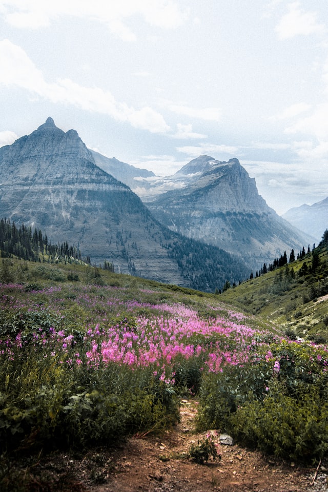
Planning a trip to Glacier National Park? Don’t miss the stunning Many Glacier region—home to some of the best hikes in the park. From easy lakeside strolls to strenuous climbs with jaw-dropping alpine views, this guide covers the best hikes in Many Glacier for every skill level. Whether you’re after a family-friendly adventure or a full-day trek, these trails deserve a spot on your Glacier National Park itinerary!

GLACIER NATIONAL PARK
Planning a visit? Check out our complete Glacier National Park travel guide featuring top things to do, best times to visit, where to stay, and more!
GLACIER National Park
Planning a visit? Check out our complete Glacier National Park travel guide featuring top things to do, best times to visit, where to stay, and more!
Many Glacier is often considered the crown jewel of Glacier National Park—and for good reason. This stunning region offers some of the park’s most iconic hikes, where you’ll find turquoise lakes, towering peaks, waterfalls, and plenty of opportunities to spot wildlife like moose and bears.
Whether you’re looking for a quick, family-friendly hike or a full-day trek into the backcountry, Many Glacier has a trail for you!
In this guide, you’ll discover the best hikes in Many Glacier—from easy strolls to challenging day hikes—to help you make the most of your Glacier National Park itinerary. Each trail includes a detailed description so you know exactly what to expect. Hikes are listed in no particular order.
Best Hikes in Many Glacier
Swiftcurrent Lake Nature Trail

- Distance: 2.6 miles
- Elevation: Flat
- Time: 2-3 hours
- Difficulty: Easy
- Trailhead: Grinnell Glacier Trailhead or Many Glacier Hotel
The Swiftcurrent Lake Nature Trail is one of the easiest and most accessible hikes in Many Glacier. This peaceful 2.6-mile loop circles Swiftcurrent Lake and offers stunning views, forested paths, and opportunities to spot wildlife—all with minimal elevation gain!
TRAIL OVERVIEW: This loop can be started from either the Many Glacier Hotel or the Grinnell Glacier Trailhead, and hiked in either direction. If you begin at the Grinnell Glacier Trailhead, the first 0.25 miles are wheelchair accessible, making it an excellent option for those with limited mobility.
However, I recommend starting from the Many Glacier Hotel, where there is typically more parking available—and some of the best views in the park await right outside the hotel.
From the shoreline here you’ll see Grinnell Point (7,600 feet) rising dramatically behind the lake, with Mount Wilbur (9,321 feet) further west in the background. It’s one of the most iconic scenes in Glacier National Park.
WHAT TO EXPECT: Heading out from the hotel, the trail winds through a serene forest filled with lodgepole pine, spruce, fir, and aspen. This stretch offers peek-a-boo views of the mountains and access to quiet beach areas along the lakeshore—perfect for a picnic or a peaceful break.
About a quarter mile in, you’ll reach a footbridge over Swiftcurrent Creek. Pause here to look for trout in the clear waters or moose in the surrounding wetlands. Shortly afterward, you’ll come to a boat dock with a fantastic vantage point—be sure to look back for a photo-worthy view of the Many Glacier Hotel framed by the surrounding peaks.
As the trail continues through another wooded section, keep your eyes peeled; black bears and grizzly bears are known to frequent this part of the trail, especially during the summer and early fall.
WHO IS THIS HIKE FOR? This loop is a perfect introduction to hiking in Glacier National Park—and a reminder that you don’t have to hike for miles to experience its beauty. It’s ideal for families, young kids, visitors short on time, hikers seeking an easy trail with big scenery, and those hoping for wildlife sightings without venturing deep into backcountry.
Lake Josephine Loop Trail
- Distance: 5.8 miles
- Elevation: 225 feet
- Time: 3-4 hours
- Difficulty: Moderate
- Trailhead: Grinnell Glacier Trailhead or Many Glacier Hotel
The Lake Josephine Loop Trail is a scenic, easy-to-moderate hike in the Many Glacier area of Glacier National Park. With its gorgeous lakeshore views, quiet forested sections, and options to shorten or extend the route, this hike is great for a wide range of ability levels.
TRAIL OVERVIEW: The Lake Josephine Loop is a relatively easy trail that loops around the entire shoreline of beautiful Lake Josephine. Starting from the Many Glacier Hotel, the trail follows the Swiftcurrent Lake Trail before connecting to the east and west shores of Lake Josephine.
This route offers serene lake views framed by dramatic alpine scenery, with glimpses of Mt. Gould and Grinnell Point reflecting in the turquoise waters. Hikers can complete the full loop or hike one side of the lake and return via the boat shuttle.
The full loop around Lake Josephine is roughly 3 miles, and when combined with the Swiftcurrent Lake Nature Trail, it totals around 5.2 miles round trip.
WHAT TO EXPECT: Starting from the Many Glacier Hotel, follow the Swiftcurrent Lake Nature Trail through a peaceful forest with filtered lake and mountain views. Eventually you’ll reach the Lake Josephine Loop Trail which will lead you around Lake Josephine.
You’ll hike for approximately 1.5 miles along the lake’s eastern shoreline before traveling back on the other side of the lake. Then rejoin the Swiftcurrent Nature Trail and return back to Many Glacier Hotel.
You can also combine this hike with a boat tour across Lake Josephine, either one-way or round-trip. This reduces mileage and gives you a unique perspective from the water.
WHO IS THIS HIKE FOR? The Lake Josephine Loop is perfect if you want to hike further than Swiftcurrent Lake without extra elevation gain, or are interested in combining your hike with a boat tour. It’s also great for spotting moose especially along the wooded eastern shore.
Iceberg Lake Trail

- Distance: 9.6 miles
- Elevation: 1,200 feet
- Time: 6-7 hours
- Difficulty: Moderate
- Trailhead: Iceberg Ptarmigan Trailhead
- Read trail guide
If you’re looking for one of the most iconic hikes in Glacier National Park, the Iceberg Lake Trail is a must. This stunning route climbs gradually through a breathtaking alpine valley, offering nonstop scenery—towering peaks, waterfalls, wildflowers, and an unforgettable glacial lake filled with floating icebergs.
TRAIL OVERVIEW: This is one of the most popular day hikes in the Many Glacier area, and for good reason. The combination of alpine beauty, high cirque walls, and the signature teal lake make this hike a Glacier highlight. This area is known for bear activity—carry bear spray and hike in groups when possible.
WHAT TO EXPECT: Start your journey at the Iceberg Ptarmigan Trailhead, located behind the Swiftcurrent Motor Inn. The trail wastes no time delivering views—almost immediately, you’ll pass through open terrain with sweeping vistas of surrounding peaks including Mount Grinnell and Mount Wilbur.
The trail then dips into a lush forested section as it gently climbs toward the lake. At around 2.5 miles, you’ll reach Ptarmigan Falls, a great spot to take a quick break. Beyond Ptarmigan Falls, the trail opens up again. Here, you’ll get your first dramatic views of the cirque that surrounds Iceberg Lake—a towering wall of rock that feels both massive and magical.
The final stretch passes through a colorful alpine meadow often dotted with wildflowers in summer, before delivering you to the icy, turquoise gem itself; Iceberg Lake.
At 6,094 feet, the lake sits in a shadowed bowl at the base of towering cliffs. Its teal water, often dotted with actual floating icebergs, is truly a sight to behold—and well worth the effort to get there!
WHO IS THIS HIKE FOR? Iceberg Lake is a great choice if you want a longer hike with a big scenic payoff, love photography, wildflowers and alpine lakes, and prepared to hike in bear country.
>>Read: Iceberg Lake Hike: A Must-Do Trail in Glacier National Park
Ptarmigan Tunnnel Trail

- Distance: 10.6 miles
- Elevation: 2,300 feet
- Time: 6-8 hours
- Difficulty: Strenuous
- Trailhead: Iceberg Ptarmigan Trailhead
The Ptarmigan Tunnel Trail is one of the most exciting hikes in Many Glacier—complete with jaw-dropping alpine scenery, a stunning high-altitude lake, wildlife viewing, and the unforgettable experience of walking through a tunnel carved into a mountain ridge. If you’re looking for a hike that’s challenging, scenic, and incredibly rewarding, this one should be at the top of your Glacier itinerary.
TRAIL OVERVIEW: The hike to Ptarmigan Tunnel begins at the Iceberg Ptarmigan Trailhead, located behind the Swiftcurrent Motor Inn. This strenuous out-and-back trail is approximately 10.7 miles round trip with about 2,300 feet of elevation gain.
It’s a challenging hike, but well worth the effort for those seeking sweeping alpine views, wildlife encounters, and a unique experience walking through a 240-foot tunnel carved into the mountainside.
Along the way, you’ll pass Ptarmigan Falls and the shimmering Ptarmigan Lake before climbing steep switchbacks to the tunnel, which opens onto a dramatic view of the remote Belly River Valley on the other side.
WHAT TO EXPECT: For the first 2.5 miles, you’ll gradually ascend the Many Glacier Valley, enjoying sweeping views of surrounding peaks before entering a shaded forest. At about 2.5 miles you’ll arrive at Ptarmigan Falls, a great place for a short break. Shortly after, a trail junction appears—turn right here to continue toward Ptarmigan Tunnel.
This next section gets steeper, climbing sharply through dense huckleberry patches—a favorite food source for bears, so make plenty of noise and stay alert. Above you, the striking Ptarmigan Wall begins to dominate the landscape.
This jagged arête—a sharp rock ridge carved by glaciers—rises dramatically, separating the Many Glacier Valley from the Belly River Valley. It’s reminiscent of the Garden Wall seen along the Highline Trail.
At around 4.5 miles, you’ll reach Ptarmigan Lake, a turquoise alpine lake nestled in a rocky basin. There’s a short spur trail down to the lake’s edge—worth the detour for a peaceful rest and a chance to spot bighorn sheep or mountain goats.
Beyond Ptarmigan Lake, the trail climbs two very steep switchbacks (this is the most challenging stretch). Then comes the highlight, the Ptarmigan Tunnel. This 240-foot passageway was blasted through the ridge in the 1930s by the Civilian Conservation Corps to allow horse tours to pass through. It’s an incredible piece of park history!
WHO IS THIS HIKE FOR? Choose this trail if you’re an experienced hiker looking for a challenging but achievable day hike, eager to explore the park’s unique features, and prepared for elevation gain, switchbacks, and wildlife encounters.
Grinnell Glacier Trail

- Distance: 10.6 miles
- Elevation: 1,600 feet
- Time: 6-8 hours
- Difficulty: Moderate-Strenuous
- Trailhead: Grinnell Glacier Trailhead or Many Glacier Hotel
The hike to Grinnell Glacier truly has it all—alpine scenery, glacier views, vibrant wildflowers, and multiple lakes in every shade of turquoise. It’s no wonder this is one of the most popular trails in the park and frequently listed among the top hikes in the United States!
TRAIL OVERVIEW: The Grinnell Glacier Trail begins at either the Grinnell Glacier Trailhead or the Many Glacier Hotel, with the full hike totaling about 10.6 miles round trip and gaining roughly 1,600 feet in elevation.
This moderately strenuous hike is one of the most iconic in Glacier National Park and delivers nonstop alpine beauty. Hikers will pass several turquoise lakes, travel through wildflower-filled meadows, and be rewarded with jaw-dropping views of Upper Grinnell Lake and the rapidly retreating Grinnell Glacier.
Wildlife sightings are common with frequent opportunities to spot mountain goats, bighorn sheep, and even grizzly bears. This is a bucket list hike for anyone visiting Glacier!
WHAT TO EXPECT: You can begin the trail at the Grinnell Glacier Trailhead or from the Many Glacier Hotel. The first two miles of the hike are relatively easy, as the trail travels along the shores of Swiftcurrent Lake and Lake Josephine with only a gentle gain in elevation. If you want to shorten the hike, you can take a shuttle boat across both lakes cutting off about 3.6 miles round trip.
Once you reach the midpoint of Lake Josephine, the trail starts to climb more steeply. This is where the views become truly spectacular, with sweeping vistas of the Grinnell Valley and Grinnell Lake far below. The exposed cliffsides are great places to spot mountain goats, while the surrounding meadows may reveal bighorn sheep or even a grizzly bear.
Push onward as the trail leads to Upper Grinnell Lake, a glacially-fed lake sitting directly beneath Grinnell Glacier and the towering Garden Wall. Icebergs often float in the lake’s vivid teal water, making for a surreal and unforgettable scene. Take in the raw beauty and reflect on the power of the glaciers that carved this magnificent landscape.
WHO IS THIS HIKE FOR? The Grinnell Glacier Trail is ideal for hikers who are up for a moderately strenuous day hike with huge scenic rewards. If you’re someone who loves panoramic views, turquoise lakes, and the chance to see a glacier up close, this hike is for you. It’s also a great choice for wildlife lovers—sightings of bighorn sheep, mountain goats, and even grizzlies are common along the trail.
Piegan Pass

- Distance: 13-16.8 miles
- Elevation: 2,650 feet
- Time: 9-11 hours
- Difficulty: Strenuous
- Trailhead: Piegan Pass Trailhead
If you’re looking for a long, challenging day hike with jaw-dropping alpine views, the hike to Piegan Pass delivers in a big way. This spectacular trail climbs steadily through forest, past waterfalls and wildflower meadows, and finishes with panoramic vistas of glacier-carved peaks at the top of the pass. While it requires endurance, the reward is one of the most scenic experiences in the Many Glacier region.
TRAIL OVERVIEW: The hike to Piegan Pass is a strenuous full-day adventure that begins near the Many Glacier Hotel and stretches to a total distance of 16.8 miles round trip. However, hikers can shave off roughly 3.8 miles by taking the shuttle boat across Swiftcurrent Lake and Lake Josephine, reducing the hike to around 13 miles.
From the boat dock at the head of Lake Josephine, a narrow spur trail climbs to a junction with the Piegan Pass Trail. From here, the trail steadily ascends through thick forest, alpine meadows, and eventually steep switchbacks to reach the top of the pass.
WHAT TO EXPECT: The trail starts with a scenic lakeside walk alongside Swiftcurrent Lake and Lake Josephine, followed by a 0.4-mile spur that climbs to connect with the Piegan Pass Trail. Early parts of the hike pass through forest and meadows with frequent glimpses of Mt. Grinnell, Angel Wing, and the Garden Wall.
At about 3.2 miles in (from Lake Josephine), you’ll arrive at Morning Eagle Falls—one of the most beautiful waterfalls in the area. Past the falls, the trail steepens and climbs through lush, flower-filled meadows before entering more rugged terrain.
A demanding set of switchbacks winds up the side of Cataract Mountain, ultimately leading you above the treeline. At 6.2 miles, the climb levels off and you’ll reach Piegan Pass with expansive views stretching in all directions. Expect snow patches into early summer, and jaw-dropping scenery the entire way.
WHO IS THIS HIKE FOR? The Piegan Pass Trail is best suited for strong day hikers with solid stamina and experience hiking in alpine environments. The trail’s length, steep elevation gains, and potential exposure to wind and weather mean it’s not ideal for beginners.
Helpful Tip: For a slightly easier alternative, take the shuttle boat across Lake Josephine or plan a point-to-point hike from Siyeh Bend catching the park shuttle bus from Going To The Sun Road back to Many Glacier.
Fishercap Lake

- Distance: 1 mile
- Elevation: Flat
- Time: 30 – 60 minutes
- Difficulty: Easy
- Trailhead: Swiftcurrent Trailhead
If you’re short on time or just want a peaceful walk in nature, Fishercap Lake is the perfect quick escape. Despite being one of the easiest hikes in the Many Glacier area, it delivers big on scenery and wildlife viewing opportunities—especially if you’re hoping to spot a moose.
TRAIL OVERVIEW: The hike to Fishercap Lake is a short, easy walk that begins at the Swiftcurrent Pass Trailhead near the Swiftcurrent Motor Inn. With virtually no elevation gain, the trail is flat and accessible, yet leads to one of the best wildlife viewing spots in Many Glacier.
It only takes 15 to 30 minutes to complete the hike, but you may find yourself lingering longer at the lake’s edge where moose are often spotted feeding in the water.
WHAT TO EXPECT: This short and simple trail begins at the Swiftcurrent Pass Trailhead and follows a wide, flat path into the forest. About 0.3 miles in, you’ll reach a marked spur trail that leads to Fishercap Lake. From there, it’s only a minute or two to the water’s edge. The lake is calm and scenic, often with reflections of the surrounding mountains on clear days.
The real draw here is the chance to see moose, especially in the early morning or late afternoon when they frequently wade into the shallows to forage. The lake is surrounded by forest,which also provides habitat for black bears, grizzly bears, and deer, so be alert and respectful of wildlife.
There are no technical challenges or steep sections on this trail, making it accessible to most hikers. Bring binoculars or a camera with zoom if you’re hoping to catch wildlife action from a safe distance.
WHO IS THIS HIKE FOR? This is an ideal hike for just about anyone. Families with young kids, travelers short on time, wildlife enthusiasts, and photographers will all find something to love here. Whether you’re out for a quick stroll or simply want to relax by a mountain lake with a good chance of seeing moose, Fishercap Lake delivers.
Redrock Lake

- Distance: 3 miles
- Elevation: 70 feet
- Time: 1-1.5 hours
- Difficulty: Easy
- Trailhead: Swiftcurrent Pass Trailhead
The hike to Redrock Lake is an easy trail in Many Glacier. Beginning at the Swiftcurrent Pass Trailhead, this hike takes you past the peaceful shores of Fishercap Lake through forested terrain to the scenic Redrock Lake. With minimal elevation gain and sweeping views of surrounding peaks, this trail is perfect for families, wildlife watchers, and anyone looking for a gentle stroll with beautiful alpine scenery.
TRAIL OVERVIEW: The hike to Redrock Lake is an easy and rewarding 3 mile round-trip trail in the Many Glacier area of Glacier National Park. Starting from the Swiftcurrent Pass Trailhead, the route meanders through forest and past Fishercap Lake—an excellent spot for moose sightings—before reaching the picturesque Redrock Lake.
WHAT TO EXPECT: The trail begins on a well-maintained path from the Swiftcurrent Pass Trailhead and quickly leads you into a shaded forest. Within the first third of a mile, you’ll reach a short spur trail down to Fishercap Lake—a serene spot that’s especially popular in the early morning or late afternoon for wildlife viewing, particularly moose.
Continuing on, the trail weaves through a mix of dense trees and open patches where you may spot wildflowers and, in season, ripe huckleberries. The forest eventually opens up to reveal the tranquil waters of Red Rock Lake, framed by dramatic alpine peaks.
The trail is generally flat and easy to follow, with only mild undulations. If you’re feeling energetic after taking in the scenery at the lake, you can extend your hike just a bit farther to visit nearby Redrock Falls.
WHO IS THIS HIKE FOR? With minimal elevation gain and sweeping views of Mount Grinnell and Swiftcurrent Mountain, this peaceful lakeside hike is perfect for families, wildlife lovers, and anyone seeking a mellow outdoor adventure in stunning alpine surroundings.
Redrock Falls

- Distance: 3.6 miles
- Elevation: 100 feet
- Time: 2 hours
- Difficulty: Easy
- Trailhead: Swiftcurrent Pass Trailhead
If you’re looking for a scenic and easy day hike in Glacier National Park, Redrock Falls is a can’t-miss trail in the Many Glacier region. This family-friendly hike winds through forest and meadows, passes two peaceful alpine lakes, and ends at one of the park’s most photogenic waterfalls.
TRAIL OVERVIEW: The hike to Redrock Falls is a scenic and easy 3.6-mile round-trip trail in the Many Glacier region of Glacier National Park. Beginning at the Swiftcurrent Pass Trailhead, the trail passes Fishercap Lake and Redrock Lake before reaching the cascading Redrock waterfall.
WHAT TO EXPECT: Start your hike at the Swiftcurrent Pass Trailhead, located near the Swiftcurrent Motor Inn. Early into the hike, you’ll come to a spur trail that leads to Fishercap Lake, a serene spot known for frequent moose sightings — especially in the early morning or late afternoon. Consider making a quick detour here either on your way in or out.
As you continue, the trail travels through a mix of shaded forest and open areas before reaching Redrock Lake, about 1.7 miles in from the trailhead. This is a great place to pause and take in the scenery with views of Mount Grinnell and Swiftcurrent Mountain reflecting in the water.
From Redrock Lake, the trail hugs the shoreline before approaching a series of distinctive red rock formations. Watch for an unmarked trail split that leads to the lower falls — don’t miss this turn!
Once at the base of Redrock Falls, you can scramble around the area for different viewpoints and even get closer to the upper cascades. The layered red rocks and tumbling water make for incredible photo ops, so bring your camera.
WHO IS THIS HIKE FOR? Redrock Falls is an ideal trail for families, beginners, or anyone looking for a short and rewarding hike in Glacier National Park. With relatively flat terrain, beautiful scenery, and a dramatic waterfall at the end, this hike delivers a lot without demanding much effort.
Swiftcurrent Pass

- Distance: 13.6 miles
- Elevation: 2,300 feet
- Time: 8-11 hours
- Difficulty: Strenuous
- Trailhead: Swiftcurrent Pass Trailhead
Looking for a challenging, less-traveled day hike in Glacier National Park with massive mountain views and a good chance of spotting wildlife? The Swiftcurrent Pass Trail in Many Glacier is a breathtaking alpine hike that winds through a dramatic glacial valley past several stunning lakes before climbing up to a panoramic mountain pass. It’s one of the most scenic—and wildest—hikes in the park!
TRAIL OVERVIEW: The Swiftcurrent Pass Trail is a challenging full-day hike that winds through the stunning Swiftcurrent Valley and climbs to a dramatic alpine pass. Along the way, hikers pass multiple scenic lakes, all framed by soaring peaks like Mount Wilbur and Swiftcurrent Mountain.
The trail begins gently but gains significant elevation in its final miles as it ascends Swiftcurrent Pass via a series of steep switchbacks. From the top, panoramic views stretch across the Many Glacier region and beyond, making this one of the most scenic hikes in the park.
WHAT TO EXPECT: Begin your journey at the Swiftcurrent Pass Trailhead, located near the Swiftcurrent Motor Inn. The first several miles of this hike travel relatively flat terrain through the scenic Swiftcurrent Valley. Along the way you’ll pass Fishercap Lake, Redrock Lake, Redrock Falls, and Bullhead Lake, all beautiful spots to stop and admire on your way up or down.
Beyond Redrock Falls, the trail narrows and becomes overgrown with dense brush. The tall vegetation encroaching the trail makes it difficult to see ahead or spot bears nearby. Grizzly bears heavily frequent this area—stay vigilant, look for signs of recent bear activity, and make plenty of noise along this stretch!
At about four miles in, the trail begins its steep ascent up to the pass. The climb includes a series of tough switchbacks, but the higher you go, the more incredible the views become.
Once you reach Swiftcurrent Pass, you’ll be treated to sweeping vistas, and those who still have energy can take the short spur trail to the Swiftcurrent Fire Lookout for an even more impressive panorama.
WHO IS THIS HIKE FOR? The Swiftcurrent Pass Trail is best suited for experienced hikers seeking a long, adventurous day hike in a less-traveled area of Glacier. It’s ideal for those who enjoy alpine scenery, remote trails, and aren’t afraid of hiking in grizzly bear territory.
The trail is long, moderately strenuous, and requires strong situational awareness. If you’re looking for a more peaceful alternative to Glacier’s popular trails and are prepared to take safety precautions, this hike is one of the most rewarding in the Many Glacier region.
Apikuni Falls Trail

- Distance: 2 miles
- Elevation: 700 feet
- Time: 1-2 hours
- Difficulty: Moderate
- Trailhead: Apikuni Parking Area
If you’re looking for a short but rewarding hike in Glacier National Park, the Apikuni Falls Trail in Many Glacier is a must. This steep but scenic trail leads to a stunning two-tiered waterfall cascading 150 feet down a rocky cliffside. It is the perfect adventure for waterfall lovers looking to stretch their legs without committing to a full-day trek.
TRAIL OVERVIEW: The Apikuni Falls Trail is a short but steep out-and-back hike in the Many Glacier area that leads to a dramatic, two-tiered waterfall cascading approximately 150 feet from a rocky cliffside. Though the trail is just one mile each way, the elevation gain makes it more challenging than it first appears.
WHAT TO EXPECT ON THE TRAIL: The hike to Apikuni Falls begins in open, grassy terrain then enters a forested area where shade offers some relief from the sun, but visibility becomes limited — stay alert and make noise for bears.
The trail climbs steadily and can feel quite steep in sections, especially for such a short hike. As you gain elevation, you’ll catch your first glimpse of Apikuni Falls through the trees. The final stretch breaks above the tree line, offering a full view of the falls.
Here, the terrain becomes rocky and may require some light scrambling if you choose to get closer to the waterfall’s base. The sound of the rushing water grows louder as you approach, and you’ll be rewarded with a spectacular close-up view of the powerful two-tiered cascade.
WHO IS THIS HIKE FOR: This hike is perfect for waterfall lovers looking for a quick adventure that still packs in big scenery. While the distance is short, the steep incline makes it better suited for those in decent shape.
If you’re looking to avoid the crowds of other popular hikes or want to warm up before tackling one of Many Glacier’s more strenuous trails, Apikuni Falls is an excellent choice. Just make sure you’re prepared for bear activity and ready to climb!
Cracker Lake Trail

- Distance: 12.6 miles
- Elevation: 1,650 feet
- Time: 7-8 hours
- Difficulty: Strenuous
- Trailhead: Cracker Lake Trailhead
The hike to Cracker Lake is one of the most underrated adventures in Glacier National Park. Tucked away in the Many Glacier area, this trail leads hikers to a breathtaking glacial lake known for its striking turquoise color and dramatic mountain backdrop. While it’s a long trek, the journey is filled with wild solitude and alpine scenery—making it a true hidden gem for those willing to put in the effort.
TRAIL OVERVIEW: This out-and-back trail begins behind the Many Glacier Hotel and leads hikers through forest, meadows, alpine ridges, and creek crossings to reach the stunning Cracker Lake. Though the trail is long, it isn’t technically difficult, making it a great option for hikers with decent endurance who are looking to escape the crowds and experience Glacier’s more secluded beauty.
WHAT TO EXPECT: The hike kicks off through a forest that skirts the edge of Sherburne Lake. About a mile in, you’ll reach Cracker Flats—an open, scenic area that offers fantastic views of Sherburne Lake and the surrounding peaks. Early morning hikers may catch the lake acting like a mirror, reflecting the mountains in its glassy surface.
From Cracker Flats, the trail reenters the forest, crossing small creeks via wooden bridges. Around the 3-mile mark, the path gains elevation with switchbacks, eventually leading to a ridge with views of Canyon Creek and Allen Creek. You’ll pass through alternating forested and open terrain with distant views of Mount Siyeh and Allen Mountain growing ever more impressive as you approach the lake.
At 5.8 miles, you’ll arrive at the north end of Cracker Lake. The lake’s vivid turquoise waters are nothing short of jaw-dropping, surrounded by dramatic, jagged peaks. While many hikers pause here, it’s worth walking another half mile to a rocky outcrop for the best views.
If you still have energy, continue to the old Cracker Lake Mine site, where abandoned mining equipment tells the story of a brief copper boom from the late 1800s. Cracker Lake also hosts a backcountry campground at the far end of the lake for those looking for an overnight adventure.
WHO IS THIS HIKE FOR? This hike is ideal for experienced hikers or fit beginners looking to challenge themselves with a longer day hike. The trail is long but not overly steep, making it a good choice for those who can handle distance and want to avoid Glacier’s more crowded trails.
Photographers and nature lovers will appreciate the jaw-dropping alpine scenery and brilliant color of the lake, while wildlife enthusiasts may enjoy spotting moose, marmots, pikas, and—yes—possibly grizzly bears.
Helpful tip: For an alternative way to reach and see Cracker Lake, book a guided horseback ride to the lake with Many Glacier Trail Rides.
Which hikes should you prioritize in Many Glacier?
Every hike on this list offers something special—the toughest part will be choosing which ones to prioritize! If you’re only spending one or two days in Many Glacier, you’ll need to decide which trails are must-dos for your itinerary.
Beginner Hikers: Fishercap Lake and the Swiftcurrent Lake Nature Trail are must-do hikes for beginners. Both are flat, easy trails that offer stunning views. Fishercap Lake is great for spotting moose early in the morning and late afternoon, while grizzly bear sightings are common on the Swiftcurrent Lake Nature Trail.
Experienced Hikers: The hike to Grinnell Glacier is the most popular hike in Many Glacier and is a must-do for experienced hikers. If you have two days, add the Iceberg Lake hike to your itinerary.
Tips for hiking in Glacier National Park

1. Start Early
Many Glacier’s trailheads fill up fast, especially in peak season (July–September). Starting early helps you avoid parking issues and also afternoon thunderstorms which are common in the mountains.
2. Bring Plenty of Water
For strenuous day hikes, be sure to carry more water than you think you’ll need. Since many trails pass streams and lakes, consider packing water purification tablets, a water-filtering bottle, or this LifeStraw water purifier for hiking in case of an emergency.
3. Dress in Layers
Weather in Glacier National Park can change quickly. Mornings may start chilly but afternoons can warm up fast. Bring a rain jacket designed for hiking in down pours, sun protection, and thermal layers—especially if you’re heading into higher elevations.
4. Carry Bear Spray—and Know How to Use It!
Glacier is grizzly country. Always carry bear spray and keep it accessible, not buried in your pack. Learn how to use it before hitting the trail, and stay alert by making noise and hiking in groups when possible.
5. Check Trail Conditions Before You Go
Many Glacier trails can be closed due to bear activity, snow, or maintenance. Always check the Glacier National Park website or visitor center for up-to-date conditions.
6. Don’t Count on Cell Service
Reception is extremely limited or nonexistent in the Many Glacier area. Download maps ahead of time (AllTrails or Gaia GPS are good options), or carry a paper map and know your route.
7. Pack Out All Trash
Glacier is a pristine wilderness area. Follow Leave No Trace principles and take everything you bring with you back out—including food wrappers, tissues, and fruit peels.
Best time to hike in Glacier National Park
The best time to hike in Many Glacier is from mid-July through mid-September, when most of the snow has melted and all trails are typically open. During this window, the alpine scenery is at its best—lush meadows are bursting with wildflowers, lakes are fully thawed, and wildlife sightings are common. Here’s a month-by-month breakdown of what to expect:
May to early June: Lower elevation trails may begin to open, but many are still wet, muddy, or partially snow-covered. Higher elevation hikes are generally still inaccessible due to lingering snowfields.
July: This is when the hiking season kicks into gear, although snow may still be present in early July at higher elevations.
August: Peak hiking season. Trails are mostly snow-free, days are warm and long, and wildflowers are abundant. However, August is also the busiest month in the park, so expect crowded trails and parking lots. Afternoon thunderstorms are common.
September: Early fall, offers fewer crowds and golden fall foliage, though cooler temperatures and early snowfall can occur.
GLACIER NATIONAL PARK
Planning a visit? Check out our complete Glacier National Park travel guide featuring top things to do, best times to visit, where to stay, and more!
GLACIER National Park
Planning a visit? Check out our complete Glacier National Park travel guide featuring top things to do, best times to visit, where to stay, and more!
Looking for a place to stay near the park? Use the interactive map below to find hotels, motels, and other lodging near Glacier National Park.