Inferno Cone Trail: A Short Hike With Epic Views in Idaho
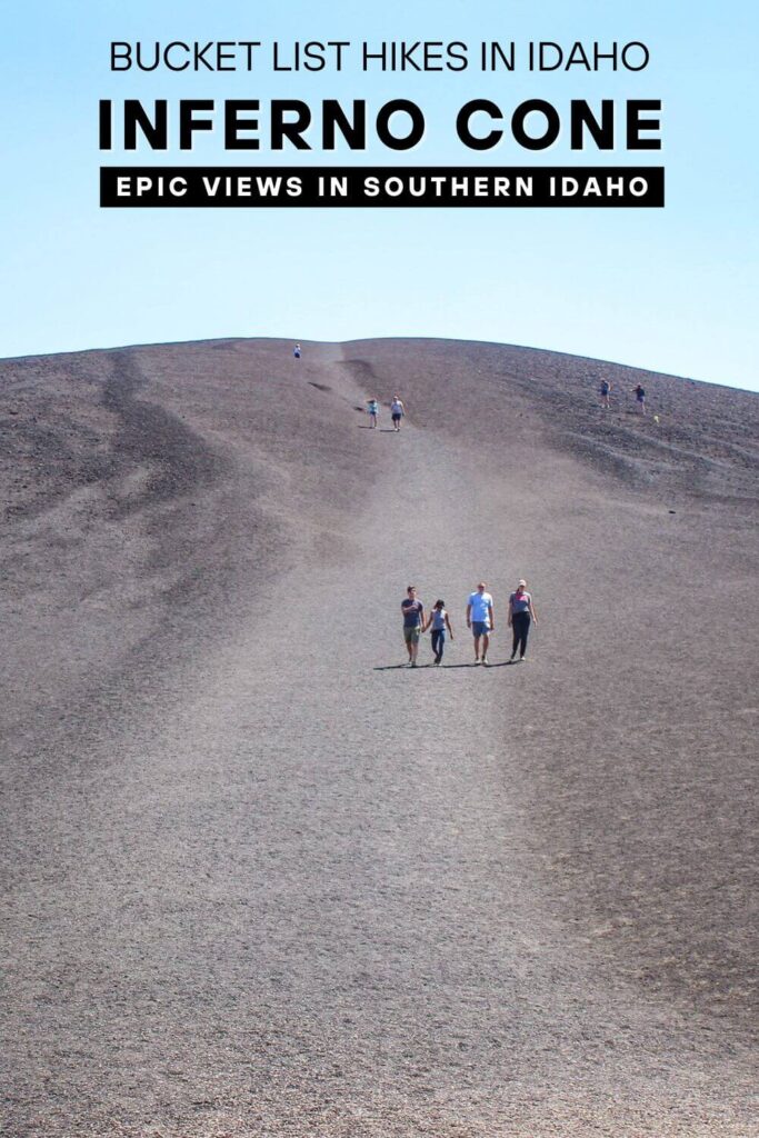
The Inferno Cone Trail is a short but steep hike in Craters of the Moon National Monument, leading to one of the best panoramic viewpoints in southern Idaho. This 0.4-mile trek rewards hikers with breathtaking 360-degree views of the park’s otherworldly lava fields, distant mountain ranges, and rugged volcanic terrain.

The Inferno Cone Trail is a short but steep hike in Craters of the Moon National Monument & Preserve, offering some of the most breathtaking panoramic views in southern Idaho!
Reaching the summit of Inferno Cone takes about 10 to 15 minutes, and the reward is well worth the effort. From the top, hikers are treated to 360-degree views of the park’s otherworldly lava fields, distant mountain ranges, and notable landmarks like Big Cinder Cone, Silent Cone, and the Great Rift.
This 0.4-mile round-trip trail may be brief, but don’t let its length fool you—the ascent is a steep climb up loose volcanic cinders, with no switchbacks to ease the incline. Despite the challenge, Inferno Cone is a must-do hike for visitors looking to experience the best of Craters of the Moon.

Trail Details
- Distance: 0.4 miles out and back
- Elevation: 160 feet
- Difficulty: Moderate
- Time: 45-60 minutes
- Restrooms: No
- Dogs: Not allowed
You might be wondering—what exactly is Inferno Cone, and how was it formed? While it may look like a small volcano, Inferno Cone is actually a cinder cone, which is the simplest type of volcanic landform, though not a true volcano itself.
A cinder cone is a steep, conical hill made up of loose volcanic fragments such as ash, cinders, and scoria that accumulate around a volcanic vent.

These fragments are formed during explosive eruptions or lava fountains, when gas-charged magma erupts violently into the air, cools rapidly, and falls back to the ground. Over time, this buildup creates a classic cone-shaped formation, often featuring a symmetrical shape with slopes between 30 and 40 degrees and a crater at the summit.
However, Inferno Cone is unique—unlike most cinder cones, it lacks a crater at its summit, making it an unusual geological feature within Craters of the Moon National Monument.
Best time to hike Inferno Cone
The best time to hike Inferno Cone is during the spring and fall months, when temperatures are mild and the volcanic landscape is more comfortable to explore.
April through June offers pleasant hiking weather with cooler mornings and wildflowers blooming in the park’s lava fields. September and October also provide ideal conditions with crisp air and fewer crowds compared to the busy summer months.
Summer (July and August) can be extremely hot, with temperatures often exceeding 90°F (32°C). Since the Inferno Cone Trail is fully exposed with no shade, hiking during the early morning or evening is recommended to avoid the intense midday heat.
Winter brings a completely different experience, as snow can blanket the lava fields, creating a stark and dramatic landscape. While the park remains open, road access may be limited due to snowfall, so be sure to check conditions before visiting.
How to hike the Inferno Cone Trail

The Inferno Cone Trail begins along the 7 Mile Loop Road at the Inferno Cone Overlook, where a large parking lot provides ample space for visitors. Several informational boards near the trailhead offer insight into the formation of cinder cones, setting the stage for your hike.
Looking up, you’ll notice something unusual—there’s no defined trail to the summit. Instead, hikers are free to march straight up the steep slope, choosing their own path to the top.

Though the hike is only 0.2 miles each way, it’s a steep, relentless climb without switchbacks to ease the ascent. Fortunately, the effort is short-lived, and in just 10 to 15 minutes, you’ll reach the summit.

At the top, you might be surprised to find that Inferno Cone lacks a crater, unlike most cinder cones. Instead, the summit is a windswept ridge dotted with patches of sagebrush and a single, resilient juniper tree, standing in stark contrast to the surrounding black volcanic soil.


The real reward, however, is the breathtaking panoramic views—some of the best in southern Idaho.
From the summit, you can see the Pioneer Mountains to the north, the Lost River Range to the northeast, home to Idaho’s tallest peak, Mount Borah (12,662 feet), and Big Southern Butte (7,550 feet) to the east, near Arco.
Within the park, notable landmarks include Paisley Cone (6,107 feet), Sunset Cone (6,410 feet), Big Cinder Cone (6,515 feet), Silent Cone, and Snow Cone, as well as an expansive lava field stretching across the landscape.


The view also provides a sweeping overview of the Great Rift, the volcanic fissure system that defines Craters of the Moon National Monument. On a clear day, miles upon miles of rugged terrain unfold in every direction.
The otherworldly landscape you see was shaped by volcanic activity relatively recently—the last eruptions occurred only 2,000 years ago, with lava flows similar to those still shaping Hawaiian volcanoes today.

Standing atop Inferno Cone, it’s easy to imagine the raw power of the Earth that formed this dramatic terrain.
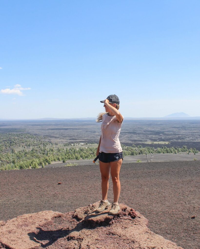


While the views are spectacular, the wind can be intense. During our hike, gusts were so strong that walking became difficult, and we had to cling to our hats the entire time.
Due to the park’s high elevation (5,900 feet) and lack of natural windbreaks, Craters of the Moon is almost always breezy, and the summit of Inferno Cone is especially exposed. Be prepared for strong gusts at the top and dress accordingly.

Take your time at the top to soak in the views, snap some photos, and appreciate the park’s volcanic beauty before making your way back down to the parking lot.
From there, continue your journey along the 7 Mile Loop Road to Stop #5: The Spatter Cones, another fascinating feature of this moon-like landscape.
Tips for hiking the Inferno Cone Trail
- Start the hike early or late evening in summer. There is no shade on the trail, and the black volcanic rock absorbs heat quickly. Hiking in the early morning or late afternoon helps avoid the worst of the heat.
- Take your time. The trail is only 0.4 miles round-trip, but the steep incline and loose footing can make it feel tougher. Go at your own pace and take breaks as needed.
- Be prepared for wind. Due to its exposed summit, Inferno Cone can be extremely windy. Bring a light jacket or windbreaker, especially in cooler months.
- Enjoy the view! Once at the top, take in the 360-degree panoramic views of the Craters of the Moon lava fields, the Pioneer Mountains, and beyond. It’s one of the best overlooks in the park!
- Craters of the Moon National Monument has an entrance fee of $20 per vehicle or $15 per motorcycle. Visitors entering on foot or by bicycle pay $10 per person. If you plan to visit multiple national parks, consider purchasing an America the Beautiful Annual Pass, which provides entry to all U.S. national parks and federal recreation sites for an entire year.
- Learn about other hikes and things to do at the park in this guide to Visiting Craters of the Moon National Preserve.
Discover more hidden gems near Inferno Cone

If you’re exploring Inferno Cone, don’t miss out on other incredible spots near Craters of the Moon National Monument & Preserve. From otherworldly volcanic landscapes to scenic alpine hikes and hidden caves, there’s plenty more to discover in this part of Idaho.
Devils Orchard Nature Trail: Just a short drive from Inferno Cone, this 0.5-mile accessible trail winds through a surreal landscape of lava fragments, twisted rock formations, and scattered cinder cones. Along the way, interpretive signs provide insight into the park’s volcanic history and ongoing conservation efforts.
Pioneer Cabin Trail: If you’re up for a more challenging adventure, head toward Sun Valley to hike the Pioneer Cabin Trail, a 8.6-mile out-and-back trek with stunning views of the Pioneer Mountains. The historic Pioneer Cabin, built in the 1930s by the Sun Valley Company, offers one of Idaho’s most iconic viewpoints, complete with the famous “The Higher You Get, The Higher You Get” message painted on the roof.
Peaks to Craters Scenic Byway: For a breathtaking drive through Idaho’s diverse landscapes, take the Peaks to Craters Scenic Byway. This high-altitude route stretches from the Sawtooth Mountains to Craters of the Moon, offering views of snow-capped peaks, rugged lava fields, and remote desert terrain. It’s the perfect way to experience the contrasts of Idaho’s natural beauty.
Shoshone Ice Caves: For a cool underground adventure, visit the Shoshone Ice Caves, located about an hour south of Craters of the Moon. These lava tubes house a natural ice formation, where temperatures remain below freezing even in the peak of summer. A guided tour through the cave reveals its fascinating geology, history, and the science behind the year-round ice.
Shoshone Falls: Known as the “Niagara Falls of the West,” Shoshone Falls is one of the most spectacular waterfalls in the country. Plunging 212 feet (higher than Niagara Falls) along the Snake River, this breathtaking natural wonder is a must-see.
Where is the Inferno Cone Trailhead?
The Inferno Cone Trailhead is located within Craters of the Moon National Monument & Preserve in Southern Idaho. It sits along the Loop Road, the park’s main scenic drive, approximately 1.5 miles past the Visitor Center.
Look for the clearly marked parking area at the base of Inferno Cone, where you’ll find an informational sign about the trail. This hike is one of the easiest to access in the park, making it a popular stop for visitors exploring Craters of the Moon.
CRATERS OF THE MOON NATIONAL MONUMENT
Planning a visit? Check out our complete Craters of the Moon travel guide featuring top things to do, scenic drives, best times to visit, where to stay, and more!

CRATERS OF THE MOON National MONUMENT AND PRESERVE
Planning a visit? Check out our complete Craters of the Moon travel guide featuring top things to do, best times to visit, where to stay, and more!
Looking for a place to stay near the park? Use the interactive map below to find hotels, motels, and other lodging near Craters of the Moon National Monument & Preserve.
Pin For Later!